Taken from the May, 1972 issue of Northeaster Caver
Years ago, Clay Perry described a reported cave near Indian Lake in the Adirondacks where someone supposedly dropped a torch in an opening and saw it vanish into blackness. Other reports claimed the existence of a large chamber inside Chimney Mountain in that area. Some eight years ago, Roger Bartholomew (who later was to join the Texas Grotto and make at least one descent into that 1050 foot Mexican Pit) led the first successful descent into this cave. On July 31, 1971, Roger, Scott Craytor, and I decided to visit and attempt mapping out Eagle Cave.
After the usual problems of rendezvousing at a place only Roger had been to before, we finally reached a Boy Scout camp somewhere southeast of Indian Lake, paid the 25 cent admission required of visitors to Chimney Mountain, and proceeded to backpack caving and camping gear up to the summit. Some 800 feet higher and 1 ½ miles away we finally bedded down for the night at 11 PM. Unfortunately a low pressure system moved into the area and gave us a good drenching. Scott was so wet that he had to head back to the cars – evidently too discouraged to return. We were not much better off but unfortunately had extra clothes.
Chimney Mountain itself is one of the most astounding sites in the Adirondacks. The whole summit looks like an atomic bomb or a 10 Richter magnitude earthquake once hit it. Talus caves and pits are everywhere; a 150-foot-deep chasm splits the summit. Eagle Cave itself is formed by massive displacements of the East Ridge.
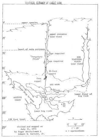
Roger and I spent about 5 hours inside that cave. There is little doubt that this is the deepest, most spectacular, toughest-to-negotiate, largest non-solution, and weirdest Adirondack cave I have encountered to date. Rappels and prussiks (see map) were not particularly long, but the configuration of the crevasse made setting them up and doing them very difficult. The 30-foot rappel starts from a narrow fault and ends up 15 feet from the nearest wall. The Big Room is 120 feet long and is adjoined by an impressive 60-foot vertical reach; beneath are several other rooms, some 20-30 feet high. Enoguh marble exists in the rock to have formed thick, white scalestone on several insoluble boulders, ear-like helictites on one rock, and long brown flowstone and “bacon” two inches thick in the lower rooms. Ice still existed up to a foot thick; yet at least one bat flew around in a warm air “pocket” higher up in the 60 foot vertical reach.
We placed the vertical relief of the cave at 130 feet and estimated a total of 500 feet of passage. Much has yet to be investigated in that area. Visitors should be aware of the fact that Eagle Cave and probably some of the others nearby are emphatically not for novices and should not be tried until July or August. This is an exciting area to study; hopefully others like it will be found in the Adirondacks.
Years ago, Clay Perry described a reported cave near Indian Lake in the Adirondacks where someone supposedly dropped a torch in an opening and saw it vanish into blackness. Other reports claimed the existence of a large chamber inside Chimney Mountain in that area. Some eight years ago, Roger Bartholomew (who later was to join the Texas Grotto and make at least one descent into that 1050 foot Mexican Pit) led the first successful descent into this cave. On July 31, 1971, Roger, Scott Craytor, and I decided to visit and attempt mapping out Eagle Cave.
After the usual problems of rendezvousing at a place only Roger had been to before, we finally reached a Boy Scout camp somewhere southeast of Indian Lake, paid the 25 cent admission required of visitors to Chimney Mountain, and proceeded to backpack caving and camping gear up to the summit. Some 800 feet higher and 1 ½ miles away we finally bedded down for the night at 11 PM. Unfortunately a low pressure system moved into the area and gave us a good drenching. Scott was so wet that he had to head back to the cars – evidently too discouraged to return. We were not much better off but unfortunately had extra clothes.
Chimney Mountain itself is one of the most astounding sites in the Adirondacks. The whole summit looks like an atomic bomb or a 10 Richter magnitude earthquake once hit it. Talus caves and pits are everywhere; a 150-foot-deep chasm splits the summit. Eagle Cave itself is formed by massive displacements of the East Ridge.
Roger and I spent about 5 hours inside that cave. There is little doubt that this is the deepest, most spectacular, toughest-to-negotiate, largest non-solution, and weirdest Adirondack cave I have encountered to date. Rappels and prussiks (see map) were not particularly long, but the configuration of the crevasse made setting them up and doing them very difficult. The 30-foot rappel starts from a narrow fault and ends up 15 feet from the nearest wall. The Big Room is 120 feet long and is adjoined by an impressive 60-foot vertical reach; beneath are several other rooms, some 20-30 feet high. Enoguh marble exists in the rock to have formed thick, white scalestone on several insoluble boulders, ear-like helictites on one rock, and long brown flowstone and “bacon” two inches thick in the lower rooms. Ice still existed up to a foot thick; yet at least one bat flew around in a warm air “pocket” higher up in the 60 foot vertical reach.
We placed the vertical relief of the cave at 130 feet and estimated a total of 500 feet of passage. Much has yet to be investigated in that area. Visitors should be aware of the fact that Eagle Cave and probably some of the others nearby are emphatically not for novices and should not be tried until July or August. This is an exciting area to study; hopefully others like it will be found in the Adirondacks.
‘Eagle Cave Discovery’ by Roger V. Bartholomew
Taken from the 4th issue in 1987 of The Northeaster Caver
Ever since I entered my first wild cave on Chimney Mountain and partially explored and named Eagle Cave in the early 1960’s both caving and the caves on Chimney Mountain have held my interest through the years. The climatology of Eagle Cave includes the increase and decrease in the masses of ice which cause annual changes in beautiful ice formations and more long term changes in accessibility of cave passages.
On March 30, 1987, I took Bob Koerber for a tour of Eagle Cave. Our passage through the upper levels of the cave was routine. The bats were hibernating in their private alcove off the Flat Rock Room in the middle levels. In the lower levels there was very little ice compared to the same time in 1983. Less precipitation this winter made less water available from the spring thaw to flow down and freeze on the cold cave walls in the lower levels.
When we entered the Ice (Blade) Room, I stopped to check the ice floor for the ice boxwork I observed in 1983 and jokingly told Bob that the bottom was 50 feet below the surface of the ice floor he was walking on. I found no ice boxwork this year, but Bob called out from the far end of the room that it dropped off! The west trending fissure had always been blocked with ice every time I had visited the cave in the past. Now it was open. Six feet beyond the end of the Ice (Blade) Room was a narrow spot in the fissure and six feet beyond that was the end of the solid ice floor and a drop off of 25 feet to an ice and rock floor. We had no rope, so we could not check it out. The fissure walls had a light coating of frost, but I knew that if more water flowed down from spring thawing and rains that the fissure could become blocked off again.
So, less than two weeks later on April 11, 1987, Robert Carroll and I were back at the fissure with vertical gear. By this time there was a ¼ to ½ inch layer of ice of the fissure walls. I chopped off an ice stalagmite near the drop to make a flat foothold, set an expansion bolt in the wall, rigged the rope, and rappelled down. The drop was measured to be 21 feet. The fissure went 20 feet more to the west and choked off. To the east one could get near the floor and look under the ice mass in the fissure for about 15 feet. The bottom of the ice mass was a knife edge that ran parallel to the fissure.
The September 16, 1978 map (see following page) of Eagle Cave shows the floor of the Ice (Blade) Room at about 28 meters (92 feet) below zero datum in the Shelter Entrance. This extra 21 feet brings the total depth to about 34.5 meters (113 feet).
Eagle cave is having more visitors these days as can be seen from the register at the trailhead. Large yellow omegas and some blue trail markings are now on the walls throughout the cave. Between the two trips reported above, someone left a “fixed” ¼” double nylon rope at the drop from Eagle Hall into the Fissure which was poorly tied off and protected. This dangerous litter was removed. Because of the cold climate in Eagle Cave an accident would be more hazardous. Access is uncontrolled and it will be only a matter of time before something happens.
Then there is always the danger of rock falls in this tectonic cave. As Bob Koerber was climbing up through a tight spot in the breakdown above the Ice (Blade) Room he said that a rock he was using as a hand hold above him had moved. He was able to let go without it moving more and he climbed down to safety. We climbed up and around by another route and from a safe position I tried to move the wedge-shaped rock which was lying at a steep angle on the wall of the passage. It weighed about 100 pounds and I carefully slid it off its delicate perch. It was fortunate that the rock did not fall when Bob was in that same spot!
‘The Naming and Some History of Eagle Cave.’ by Roger V. Bartholomew
Taken from the June, 1991 issue of Northeaster Caver
In the summer of 1963 Don Devitt took me on my first caving trip to Chimney Mountain in the Adirondacks of New York State. Don had learned cave exploring from the Pittsburgh Grotto and became an NSS member while he was studying at Carnegie Tech. I had never been caving before but I became interested when I heard about ice caves on Chimney Mountain from an old timer in Inlet, N.Y. Don found a library copy of Underground Empire written by Clay Perry in 1948 and found a few passages about Chimney Mountain which further sharpened my curiosity: “One of the most remarkable examples of a mountain cave is described by A.T. Storey. It is at Chimney Mountain and is so deep that a candle lowered on a string went out of sight” (p. 157) and “the cavern appears as a curious chimney within a chimney, so to speak. So far as is known no one has ever reached its bottom, perhaps because on one brought along enough rope, and here is a challenge to spelunkers and mountaineers par excellence” (p. 159).
On that first trip to Chimney Mountain in the summer of 1963 we started searching on the west side of the west ridge. I was surprised when Don started to squeeze into tiny fissures and cracks. So this is what cave exploring was about. I was not uncomfortable in tight places. I was very curious about where the passages went. And so I got the caving bug.
We kept working our way up the west ridge checking out the cracks and fissures and entered our first significant cave. We climbed down a hole in the rocks and traveled horizontally for about 20 feet over a sand floor to the end. We called it Bottle Cave.
The next cave was found under the nose of a pointed rock outcrop. It began as a tight crawl which after a few feet intersected a 4 foot high fissure entering from the left which came from another entrance. Continuing straight ahead we came to an ice plug, but through a small hole we could see a large room beyond. We had no tools to chop through.
Exploring around on the surface we began to get a picture of the terrain at the top of Chimney Mountain. Huge slabs, blocks of rock and even the side of the mountain are shattered, fissured, tilted, upthrusted, and slumped over at various angles. The caves had not been formed by solution but by a geological catastrophe.
Several weeks later we returned with a meat cleaver and chopped our way into the room. It was about 25-30 feet long and along the left wall was a climbdown through rocks to a sloping smooth ice slide which was impossible without rope. Somewhere in this area we saw strange black cryptographic writing on the wall: “G.W. NSS 5021 (or 3021)” with the date 1955. We tied off a rope and explored the ice slide down for about 20 feet where it ended. Back up in the large room we found a passage at the opposite end from which we entered. We followed it up to a ten foot pit and climbed out of the third entrance to the cave.
We entered another cave entrance at the south head of the ravine between the east and west ridges which seemed to be clogged with ice. We checked out several small holes just below the east rim of the west ridge and found passage leading to a too narrow fissure blowing cold air which widened out and went deep.
In late August or early September of 1963 we made another recon trip to Chimney Mountain. We brought along Bill Fehlner of Dolgeville, N.Y. for a tour of Chimney Mountain. We explored several small caves and fissures in the north end of the ravine along the west ridge and I climbed the chimney for the first time.
At the highest point of the west ridge one gets a good view to the east of the “chimney,” a dome shaped block of rock across the ravine resting on an upthrusted stratified base. Looking north there is a beautiful view of a wide valley with Blue Mountain at its head. Off to the northeast one can see far off in the distance some of the high peaks of the Adirondacks. From east to southeast the bulk of Bullhead Mountain looms over the chimney. Turning west one can see the rocky dome of Snowy Mountain, the highest peak in this area of the Adirondacks. About 45 degrees to the left one can look down on the cabins, trail head and King’s Flow about 900 feet below. At this highest point on the top of the west ridge is a “V” shaped depression in the rock. We paused here at this vantage point taking in the panoramic view and had lunch. I named this vantage point: The Eagle’s Nest.
Looking down from the Eagle’s Nest into the ravine once can see a fissure which runs down the east side of the west ridge and which penetrates into the west ridge a bit to the right of the Eagle’s Nest. It is blocked on top near the Eagle’s Nest but about 10 feet below one can squeeze through and identify the top of the fissure. Farther down the ravine the fissure gets wider. Don checked it out and noticed that about 25 feet down from the Eagle’s Nest one can more easily enter the fissure, but we decided not to enter without rope. We ended our 1963 explorations without finding that deep cave into which a candle could be lowered out of sight.
By the summer of 1964 I had acquired a new 150 foot length of ½ inch Dupont 707 twisted white nylon rope and had been instructed by Don in the use of 3 knot manila prussiks. Also, Don showed me how to rappel by running the rope through a locking “D” ring on the seat sling and up over a leather shoulder patch and down around the back and across the thigh for friction. We were ready to check out the fissure.
On the first exploration of the fissure in the summer of 1964 I chimneyed in level with the entry point. Don Devitt followed the floor. About 10 feet in Don chimneyed down Purgatory Pitch to the floor and continued in. I chimneyed about 20 feet above 10 feet ahead of Don with the 150 foot nylon rope over my shoulder. About 25 feet in the fissure Don warned me not to slip down because the fissure below me opened into the ceiling of a large room. I chimneyed back and worked my way down to the floor. The fissure was narrow and we had to take turns and move along sideways to the point where the floor of the fissure dropped 15 feet to the floor of the large room. The rope was tied off on a rock on the floor back along the floor of the fissure and we rappelled down into a huge room. At our landing point we could see that the fissure continued down through large breakdown on the floor. First, we explored to the left end of the huge room which intersected a high fissure which narrowed at the top. The bottom of the high fissure on the left was full of snow and ice. The top of the right end of the fissure went upward and seemed to be blocked with rocks. Going back into the huge room we explored the right end. We worked our way through the boulders climbing downward through the rocks and ice until we reached a deep lower room with a boulder strewn floor and large ice flows on one wall. After about four hours of exploring we found our way back to the huge room and used our 3 knot manila prussiks to get up the 15 foot drop. It was tough getting the prussic knots over the lip where the rope was tight against the rock.
We had found a big deep cave. We were elated. We found no signs that others had entered the cave. I named it: Eagle Cave because it was right below the Eagle’s nest.
In the spring of 1970 I wrote to a Scott Craytor from my military base in San Antonio, Texas asking if he knew of any New York State cavers who could help me do some mapping in upstate N.Y. on July 24, 1970 when I would be home in Rome, N.Y. on leave. Scott informed me, “There isn’t anything new up there in the Adirondacks…give me a location of your cave – maybe I can send you a grade 5 survey” and sent me the names: Chuck Porter, Pete Teresco, Dick Jarvis, Dave DeArmond, and Ron Aycock. Without mentioning the name or location of the cave I wrote to each of them on July 18, 1970, but the time was too short and neither Scott nor the others could make it. The mapping trip was cancelled.
Chuck Porter forwarded a copy of my letter to him to a Robert Carroll of Potsdam, NY. Robert wrote on August 16, 1970 to my San Antonio address. After introducing himself, Robert speculated on the location of this cave because I had not told anyone my name for or the location of the cave. I wrote back to Robert that I called it Eagle Cave and it was on Chimney Mountain. On September 13, 1970, Robert wrote back, “Thanks for the reassurances that Eagle Cave is not in the ‘endangered zone’ [of a proposed dam] but he did not know the location: “I couldn’t locate any Chimney Mountain on any maps I could get ahold of…” And so Robert Carroll became the first New York State caver to see the name of Eagle Cave for that big cave on Chimney Mountain.
After a series of letter with Robert, a survey trip to Eagle Cave was set up for the summer on 1971. On Friday night July 30, 1971 Robert Carroll, Scott Craytor and I hiked up Chimney Mountain and camped out. During the night it rained. Scott Craytor’s sleeping bag got soaked and at 5AM he hiked down and left for home. On the morning of July 1, 1971 Robert Carroll and I entered Eagle Cave through the fissure entrance in the ravine below the Eagle’s Nest. I set the zero datum of the survey at the highest point of the fissure located about 10 feet below the level of the Eagle’s Nest. When the survey reached the rope drop, I set a bolt in the left wall to keep the rope off the lip and we repelled into the cold. After having caved in Texas where the average cave temperature is in the high sixties, I had forgotten about and did not properly dress for the 32 degrees F. of Eagle Cave and could not endure a long trip. I decided I could only manage a quick hand held survey to a deep point. We surveyed directly down the fissure into the floor of the room Devitt and I had reached in 1964. It was 120 feet below the zero datum. I noted in my survey book some names we found on a rock in this deep room: R. Soron, D. Burgorne, M. Gillman 7-10-69.
Since I had to leave New York State two weeks after this trip, it was many years before I got back to Eagle Cave again. Meanwhile, Robert Carroll had alerted other northeast cavers to the existence of a large tectonic cave on Chimney Mountain called Eagle Cave. On August 325, 1975 Robert Carroll wrote to me: “During the ADK Grotto outing August 23, Dave Allured, Dick Kaba, Brad Smith, Ron Sloan and I went up there [Eagle Cave] and ended up doubling its size.” Robert Carroll included in this letter his first sketch map of Eagle Cave dated 8-23-75. On September 29, 1975 Robert Carroll wrote to me: “…during the Fall NRO in the southeastern Adirondacks Sept. 27-28…Eagle Cave has more than tripled in passage (L>1600 ft. as of now)…” On October 26, 1975 Robert Carroll wrote to me: “Some cavers in the Bostson Grotto have tried a Grade-5 Survey [of Eagle Cav]…”
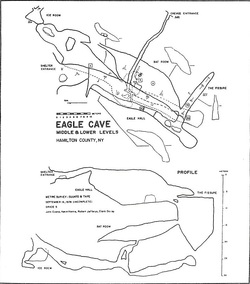
On October 22-23, 1977 Alan Henshaw, a British caver, and I came down from Toronto, Ontario and Robert Carroll guided my first trip through the Shelter Entrance and Eagle Hall. Because I had always entered Eagle Cave by the fissure below the Eagle’s Nest, I had never known of the Shelter Entrance and the large Eagle Hall.
On August 5-10, 1979 I attended my first complete NSS Convention in Pittsfield, Mass. And on page 67 of the Guide Book was the first plot and draft map of a survey of Eagle Cave done by John Evans, Kevin Harris, Robert Jeffreys and Clark Dailey.
On a October 22, 1983 trip with Robert Carroll through Eagle Hall, I noticed and erased the word “crevice” and an arrow someone had written in white chalk high on the east wall near the ceiling. Following the direction or the erased arrow I got my first view into the west end of the Crevice Entrance. If one looks horizontally into this crevice one can see light entering from the Crevice Entrance in the ravine. If one looks vertically down the fissure, one sees blackness. I speculate that this is the point where the candle was lowered out of sight and described in the quotes from Clay Perry’s book. Therefore, it is probable that the Shelter Entrance and Eagle Hall had been known for a long time before Don Devitt and I entered the Bat Room and lower levels back in the summer of 1964. However, I find it hard to believe that no one ever tried to climb down the 15 foot drop at the south end of Eagle Hall into the Fissure. If no one did, it may have been because a rope was lacking or because the opening to the Bat Room was not visible from the top of the drop or it was plugged.
I do wonder if an older name exists for Eagle Cave. There are so many caves up there that careful research is needed to associate a previous name with a presently known cave. Another mystery is the name of the NSS member who wrote on the walls of the ice slide cave in 1955. The NSS office could not find a name to fit the initials, NSS number and date, I remembered. Perhaps someone reading this can solve the mystery.
One year before that NSS member wrote on the walls of what I now call Ice Slide Cave, the NSS Bulletin, #16, 1954, pg. 22 & 24 published William Halliday’s comments on Chimney Mountain: “There has long been discussion of the exact nature of the ice caves on Chimney Rock Mountain, N.Y. They have been variously considered as limestone, talus, fissure, and gorge caves.” Bill included correctly the Chimney Mountain ice caves on a list of Fissure and Sink Glaceries having permanent or semi-permanent ice deposits. I am told that Eagle Cave is a tectonic cave formed in igneous rock.
Several interesting formations occur in Eagle Cave. Between the lowest room under the crevice Entrance and the Ice Blade Room is a horizontal stoopway. It can be entered by rappelling down the holes in the floor of the Bat Room under the Crevice Entrance and going northeast. It is entered most easily via either of two passages at the northeast end of the Bat Room which lead to a middle level room I call the Flat Rock Room. Then one enters a downward sloping crawl under the Flat Rock which leads to the Stoopway. At the point where the Stoopway is entered one can see small dark flowstone-like formations on the wall formed by water flowing out of cracks. The rocks below are splashed with a black coating. The formation itself is soft and can be scraped off easily. On April 23, 1983 I sent a sample to Carol Hill. By June 30, 1983 John Husler of the Department of Geology of the U. of New Mexico wrote that it gave no x-ray diffraction and therefore it “is not actually a crystalline mineral; rather it is an amorphous compound or compounds, probably consisting of oxides of iron.” On August 17, 1983 Husler wrote that an SEM test showed it had iron and minor amounts of calcium and silicon. Also on August 17, 1983 Carol Hill wrote: “Report the iron oxide (rust) mineral as limonite-A FeO2…It is a fairly rare mineral and an important discovery and should be in the literature.” On January 5, 1985 the rock just below the limonite was covered with a thin layer of clear ice which caused varying shaded of bright yellow to appear on the normally black rock! The presence of iron can affect survey compass bearings!
On the October 23, 1983 trip I took a sample of white crust that lies on some rocks in Eagle Hall. John Husler identified it on March 22, 1984 as “almost pure gypsum, CaSO4+2H2O. There may be a trace of brushite, but there is only 0.017 phosphorus as P205.”
I do not remember when I first entered the Ice Room, one of the lowest rooms in Eagle Cave, but my observations since 1977 have noticed a long term trend: the amount of ice in the Ice Room is decreasing. On October 23, 1977 I photographed an ice stalagmite formation [The Ice Blade] in the Ice Room. By August 4, 1979 it had decreased in size and by March 16, 1983 just a flat ice floor existed on the spot. On March 30, 1987 Bob Koerber observed that a fissure just beyond the former spot of the Ice Blade, which had always been clogged with ice flow, had opened up. I squeezed into the fissure for about 12 feet and peered over a 20 foot drop in the ice floor. On April 11, 1987 Robert Carroll and I returned before the fissure got iced up and I rappelled down and extended the depth of Eagle Cave in this area by 21 feet. The floor of the Ice Room was actually a block of ice 20 feet thick wedged in a fissure. The bottom of the block was a sharp ice edge parallel to the fissure and dripping water.
There are interesting annual variations of Eagle Cave meterology about which the hibernation of bats throughout the cold Adirondack winter provides important information. In his September 29, 1975 letter Robert Carroll said, “It turns out that some parts of the cave [Eagle Cave] can sustain bat hibernation through the winter, but other parts may be perpetually subfreezing.” On October 23, 1977 Robert Carroll, Alan Henshaw and I observed a large number of bats in the Flat Rock Room. But since this was in the fall, hibernation throughout the winter was not proven.
But on a March 26, 1983 trip to Eagle Cave with my nephew Matthew Bartholomew I was shocked to find hibernating bats in the Bat Room and in the Flat Rock Room. The bats tended to eb in clusters and one large cluster was about 1.5 feet in diameter. Also a few bats were flying around! In the Ice Room a small thermometer Matt happened to be carrying read 23 degrees F. A ½ inch thick ice crust was on the floor of the Ice Room. And 1 ½ inches below it was a fantastic display of ice boxwork with ¾ ice crystals jutting up from the partitions into the space below the ice crust! On April 9, 1983 I returned with my cousin Gary DelNero to photograph the ice boxwork but my camera failed. The bats were still hibernating in the Bat Room and the Flat Rock Room and a few were observed flying around. The Ice Room was at 30.5 degrees F. We had to be very careful in Eagle Hall, the highest room, because the walls and floor were covered with slippery frost crystals. On April 23, 1983 I went with Matthew again and got photographs of the ice boxwork. The Ice Room was now 31.5 deg. F. The bats were still in hibernation in the Bat Room and Flat Rock Room and a few were observed flying around. A key observation on this last trip was that the ice stalagmites were growing and clear ice flows on the walls were building up at the middle and lower levels of the cave.
On February 24, 1984 I took Bob Lubeck, a high school classmate of mine and an accomplished nature photographer, to photograph the bats. On January 5, 1985 Bob Lubeck was along for more photography when I guided Al Breisch, Paul Novak, and Al Hicks of the Endangered Species Section of the N.Y.S. Department of Environmental Conservation on a bat census of the hibernating bats in Eagle Cave. They recorded 2575 Little Brown Bats, 7 Keane Bats, and 53 Small Footed Bats. Their electronic thermometer gave the following readings: 11 deg. F. Outside Air Temp.; 27 deg. F. in Eagle Hall at the 15 foot drop into The Fissure; 36 deg. F. Rock Temp; and 37 deg. F. Air Temp just inside the Bat Room on the right wall where lots of bats were roosting; 32 deg. F. in draft coming into the ceiling of the Bat Room from the Crevice Entrance; 34 deg. Air and 33 deg. Rock temp. in a group of Small Footed Bats hibernating 20 feet from the Crevice Entrance fissure near the floor of the Bat Room; 35-36 deg. F. at far north end of Bat Room; 37.5 deg. F. Air and 36 deg. F. Rock temp near a bat hibernating in the Ice Candle Room. The Ice Candle Room is at the lower middle level of the cave approximately above the Ice Room. I had noticed that the least amount of ice is found in Eagle Cave in the dead of winter. But during the weeks of late March and early April beautiful displays of ice formations form in all levels of the cave as the water from the melting snow or rain on the surface flows or drips into the cave and freezes.
These meteorological and biological observations indicate that during the summer months warm air flowing through the middle levels of the cave heats the rock walls to such an extent that they act as a heat storage bed to keep bats alive in hibernation throughout the Adirondack winter. During the winter, cold air from the entrance plunges through the holes in the floor of the Bat Room and flows northeast along the Stoopway passage to the Ice Candle Room and down to the Ice Room. This cold air takes heat from the rocks and lowers the rock and air temperature below freezing. In the Spring, water from melting snow and rain on the surface flows down into the cave and freezes producing ice flows and photogenic displays of ice formations. The warm air flowing in from spring to early fall and the heat stored in the rock walls continues to melt these ice formations until the late fall when infiltrating cold air again cools the rock walls of the cave. In winter most water is held on the surface in the snow and ice and so in the winter months the least amount of ice is present in Eagle Cave. However, the Ice Room being at the lowest level acts as a cold trap sufficient to hold large amounts of ice frozen throughout the year. The long term loss of ice volume in the Ice Room can be due to a number of factors; less surface precipitation, climate warming, caver visitation, etc.
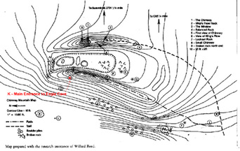
The formation of the tectonic caves on Chimney Mountain is a subject meriting interesting speculations. One hypothesis I heard was that an upthrust occurred and what is now the west ridge slumped over to the west forming the ravine, and the caves and fissures in the west ridge. The narrow east ridge with the chimney remained in the upthrusted position. I am tempted to hypothesize that an undercut massive structure, what is now the west ridge, slumped over and pryed up the east ridge by level action. If this occurred there could be a large room somewhere deep under the east ridge. In fact when one hikes down from the east ridge into the ravine near the south end, one passes a small hole which leads into the east ridge which blows cold air.
In the summer of 1963 Don Devitt took me on my first caving trip to Chimney Mountain in the Adirondacks of New York State. Don had learned cave exploring from the Pittsburgh Grotto and became an NSS member while he was studying at Carnegie Tech. I had never been caving before but I became interested when I heard about ice caves on Chimney Mountain from an old timer in Inlet, N.Y. Don found a library copy of Underground Empire written by Clay Perry in 1948 and found a few passages about Chimney Mountain which further sharpened my curiosity: “One of the most remarkable examples of a mountain cave is described by A.T. Storey. It is at Chimney Mountain and is so deep that a candle lowered on a string went out of sight” (p. 157) and “the cavern appears as a curious chimney within a chimney, so to speak. So far as is known no one has ever reached its bottom, perhaps because on one brought along enough rope, and here is a challenge to spelunkers and mountaineers par excellence” (p. 159).
On that first trip to Chimney Mountain in the summer of 1963 we started searching on the west side of the west ridge. I was surprised when Don started to squeeze into tiny fissures and cracks. So this is what cave exploring was about. I was not uncomfortable in tight places. I was very curious about where the passages went. And so I got the caving bug.
We kept working our way up the west ridge checking out the cracks and fissures and entered our first significant cave. We climbed down a hole in the rocks and traveled horizontally for about 20 feet over a sand floor to the end. We called it Bottle Cave.
The next cave was found under the nose of a pointed rock outcrop. It began as a tight crawl which after a few feet intersected a 4 foot high fissure entering from the left which came from another entrance. Continuing straight ahead we came to an ice plug, but through a small hole we could see a large room beyond. We had no tools to chop through.
Exploring around on the surface we began to get a picture of the terrain at the top of Chimney Mountain. Huge slabs, blocks of rock and even the side of the mountain are shattered, fissured, tilted, upthrusted, and slumped over at various angles. The caves had not been formed by solution but by a geological catastrophe.
Several weeks later we returned with a meat cleaver and chopped our way into the room. It was about 25-30 feet long and along the left wall was a climbdown through rocks to a sloping smooth ice slide which was impossible without rope. Somewhere in this area we saw strange black cryptographic writing on the wall: “G.W. NSS 5021 (or 3021)” with the date 1955. We tied off a rope and explored the ice slide down for about 20 feet where it ended. Back up in the large room we found a passage at the opposite end from which we entered. We followed it up to a ten foot pit and climbed out of the third entrance to the cave.
We entered another cave entrance at the south head of the ravine between the east and west ridges which seemed to be clogged with ice. We checked out several small holes just below the east rim of the west ridge and found passage leading to a too narrow fissure blowing cold air which widened out and went deep.
In late August or early September of 1963 we made another recon trip to Chimney Mountain. We brought along Bill Fehlner of Dolgeville, N.Y. for a tour of Chimney Mountain. We explored several small caves and fissures in the north end of the ravine along the west ridge and I climbed the chimney for the first time.
At the highest point of the west ridge one gets a good view to the east of the “chimney,” a dome shaped block of rock across the ravine resting on an upthrusted stratified base. Looking north there is a beautiful view of a wide valley with Blue Mountain at its head. Off to the northeast one can see far off in the distance some of the high peaks of the Adirondacks. From east to southeast the bulk of Bullhead Mountain looms over the chimney. Turning west one can see the rocky dome of Snowy Mountain, the highest peak in this area of the Adirondacks. About 45 degrees to the left one can look down on the cabins, trail head and King’s Flow about 900 feet below. At this highest point on the top of the west ridge is a “V” shaped depression in the rock. We paused here at this vantage point taking in the panoramic view and had lunch. I named this vantage point: The Eagle’s Nest.
Looking down from the Eagle’s Nest into the ravine once can see a fissure which runs down the east side of the west ridge and which penetrates into the west ridge a bit to the right of the Eagle’s Nest. It is blocked on top near the Eagle’s Nest but about 10 feet below one can squeeze through and identify the top of the fissure. Farther down the ravine the fissure gets wider. Don checked it out and noticed that about 25 feet down from the Eagle’s Nest one can more easily enter the fissure, but we decided not to enter without rope. We ended our 1963 explorations without finding that deep cave into which a candle could be lowered out of sight.
By the summer of 1964 I had acquired a new 150 foot length of ½ inch Dupont 707 twisted white nylon rope and had been instructed by Don in the use of 3 knot manila prussiks. Also, Don showed me how to rappel by running the rope through a locking “D” ring on the seat sling and up over a leather shoulder patch and down around the back and across the thigh for friction. We were ready to check out the fissure.
On the first exploration of the fissure in the summer of 1964 I chimneyed in level with the entry point. Don Devitt followed the floor. About 10 feet in Don chimneyed down Purgatory Pitch to the floor and continued in. I chimneyed about 20 feet above 10 feet ahead of Don with the 150 foot nylon rope over my shoulder. About 25 feet in the fissure Don warned me not to slip down because the fissure below me opened into the ceiling of a large room. I chimneyed back and worked my way down to the floor. The fissure was narrow and we had to take turns and move along sideways to the point where the floor of the fissure dropped 15 feet to the floor of the large room. The rope was tied off on a rock on the floor back along the floor of the fissure and we rappelled down into a huge room. At our landing point we could see that the fissure continued down through large breakdown on the floor. First, we explored to the left end of the huge room which intersected a high fissure which narrowed at the top. The bottom of the high fissure on the left was full of snow and ice. The top of the right end of the fissure went upward and seemed to be blocked with rocks. Going back into the huge room we explored the right end. We worked our way through the boulders climbing downward through the rocks and ice until we reached a deep lower room with a boulder strewn floor and large ice flows on one wall. After about four hours of exploring we found our way back to the huge room and used our 3 knot manila prussiks to get up the 15 foot drop. It was tough getting the prussic knots over the lip where the rope was tight against the rock.
We had found a big deep cave. We were elated. We found no signs that others had entered the cave. I named it: Eagle Cave because it was right below the Eagle’s nest.
In the spring of 1970 I wrote to a Scott Craytor from my military base in San Antonio, Texas asking if he knew of any New York State cavers who could help me do some mapping in upstate N.Y. on July 24, 1970 when I would be home in Rome, N.Y. on leave. Scott informed me, “There isn’t anything new up there in the Adirondacks…give me a location of your cave – maybe I can send you a grade 5 survey” and sent me the names: Chuck Porter, Pete Teresco, Dick Jarvis, Dave DeArmond, and Ron Aycock. Without mentioning the name or location of the cave I wrote to each of them on July 18, 1970, but the time was too short and neither Scott nor the others could make it. The mapping trip was cancelled.
Chuck Porter forwarded a copy of my letter to him to a Robert Carroll of Potsdam, NY. Robert wrote on August 16, 1970 to my San Antonio address. After introducing himself, Robert speculated on the location of this cave because I had not told anyone my name for or the location of the cave. I wrote back to Robert that I called it Eagle Cave and it was on Chimney Mountain. On September 13, 1970, Robert wrote back, “Thanks for the reassurances that Eagle Cave is not in the ‘endangered zone’ [of a proposed dam] but he did not know the location: “I couldn’t locate any Chimney Mountain on any maps I could get ahold of…” And so Robert Carroll became the first New York State caver to see the name of Eagle Cave for that big cave on Chimney Mountain.
After a series of letter with Robert, a survey trip to Eagle Cave was set up for the summer on 1971. On Friday night July 30, 1971 Robert Carroll, Scott Craytor and I hiked up Chimney Mountain and camped out. During the night it rained. Scott Craytor’s sleeping bag got soaked and at 5AM he hiked down and left for home. On the morning of July 1, 1971 Robert Carroll and I entered Eagle Cave through the fissure entrance in the ravine below the Eagle’s Nest. I set the zero datum of the survey at the highest point of the fissure located about 10 feet below the level of the Eagle’s Nest. When the survey reached the rope drop, I set a bolt in the left wall to keep the rope off the lip and we repelled into the cold. After having caved in Texas where the average cave temperature is in the high sixties, I had forgotten about and did not properly dress for the 32 degrees F. of Eagle Cave and could not endure a long trip. I decided I could only manage a quick hand held survey to a deep point. We surveyed directly down the fissure into the floor of the room Devitt and I had reached in 1964. It was 120 feet below the zero datum. I noted in my survey book some names we found on a rock in this deep room: R. Soron, D. Burgorne, M. Gillman 7-10-69.
Since I had to leave New York State two weeks after this trip, it was many years before I got back to Eagle Cave again. Meanwhile, Robert Carroll had alerted other northeast cavers to the existence of a large tectonic cave on Chimney Mountain called Eagle Cave. On August 325, 1975 Robert Carroll wrote to me: “During the ADK Grotto outing August 23, Dave Allured, Dick Kaba, Brad Smith, Ron Sloan and I went up there [Eagle Cave] and ended up doubling its size.” Robert Carroll included in this letter his first sketch map of Eagle Cave dated 8-23-75. On September 29, 1975 Robert Carroll wrote to me: “…during the Fall NRO in the southeastern Adirondacks Sept. 27-28…Eagle Cave has more than tripled in passage (L>1600 ft. as of now)…” On October 26, 1975 Robert Carroll wrote to me: “Some cavers in the Bostson Grotto have tried a Grade-5 Survey [of Eagle Cav]…”
On October 22-23, 1977 Alan Henshaw, a British caver, and I came down from Toronto, Ontario and Robert Carroll guided my first trip through the Shelter Entrance and Eagle Hall. Because I had always entered Eagle Cave by the fissure below the Eagle’s Nest, I had never known of the Shelter Entrance and the large Eagle Hall.
On August 5-10, 1979 I attended my first complete NSS Convention in Pittsfield, Mass. And on page 67 of the Guide Book was the first plot and draft map of a survey of Eagle Cave done by John Evans, Kevin Harris, Robert Jeffreys and Clark Dailey.
On a October 22, 1983 trip with Robert Carroll through Eagle Hall, I noticed and erased the word “crevice” and an arrow someone had written in white chalk high on the east wall near the ceiling. Following the direction or the erased arrow I got my first view into the west end of the Crevice Entrance. If one looks horizontally into this crevice one can see light entering from the Crevice Entrance in the ravine. If one looks vertically down the fissure, one sees blackness. I speculate that this is the point where the candle was lowered out of sight and described in the quotes from Clay Perry’s book. Therefore, it is probable that the Shelter Entrance and Eagle Hall had been known for a long time before Don Devitt and I entered the Bat Room and lower levels back in the summer of 1964. However, I find it hard to believe that no one ever tried to climb down the 15 foot drop at the south end of Eagle Hall into the Fissure. If no one did, it may have been because a rope was lacking or because the opening to the Bat Room was not visible from the top of the drop or it was plugged.
I do wonder if an older name exists for Eagle Cave. There are so many caves up there that careful research is needed to associate a previous name with a presently known cave. Another mystery is the name of the NSS member who wrote on the walls of the ice slide cave in 1955. The NSS office could not find a name to fit the initials, NSS number and date, I remembered. Perhaps someone reading this can solve the mystery.
One year before that NSS member wrote on the walls of what I now call Ice Slide Cave, the NSS Bulletin, #16, 1954, pg. 22 & 24 published William Halliday’s comments on Chimney Mountain: “There has long been discussion of the exact nature of the ice caves on Chimney Rock Mountain, N.Y. They have been variously considered as limestone, talus, fissure, and gorge caves.” Bill included correctly the Chimney Mountain ice caves on a list of Fissure and Sink Glaceries having permanent or semi-permanent ice deposits. I am told that Eagle Cave is a tectonic cave formed in igneous rock.
Several interesting formations occur in Eagle Cave. Between the lowest room under the crevice Entrance and the Ice Blade Room is a horizontal stoopway. It can be entered by rappelling down the holes in the floor of the Bat Room under the Crevice Entrance and going northeast. It is entered most easily via either of two passages at the northeast end of the Bat Room which lead to a middle level room I call the Flat Rock Room. Then one enters a downward sloping crawl under the Flat Rock which leads to the Stoopway. At the point where the Stoopway is entered one can see small dark flowstone-like formations on the wall formed by water flowing out of cracks. The rocks below are splashed with a black coating. The formation itself is soft and can be scraped off easily. On April 23, 1983 I sent a sample to Carol Hill. By June 30, 1983 John Husler of the Department of Geology of the U. of New Mexico wrote that it gave no x-ray diffraction and therefore it “is not actually a crystalline mineral; rather it is an amorphous compound or compounds, probably consisting of oxides of iron.” On August 17, 1983 Husler wrote that an SEM test showed it had iron and minor amounts of calcium and silicon. Also on August 17, 1983 Carol Hill wrote: “Report the iron oxide (rust) mineral as limonite-A FeO2…It is a fairly rare mineral and an important discovery and should be in the literature.” On January 5, 1985 the rock just below the limonite was covered with a thin layer of clear ice which caused varying shaded of bright yellow to appear on the normally black rock! The presence of iron can affect survey compass bearings!
On the October 23, 1983 trip I took a sample of white crust that lies on some rocks in Eagle Hall. John Husler identified it on March 22, 1984 as “almost pure gypsum, CaSO4+2H2O. There may be a trace of brushite, but there is only 0.017 phosphorus as P205.”
I do not remember when I first entered the Ice Room, one of the lowest rooms in Eagle Cave, but my observations since 1977 have noticed a long term trend: the amount of ice in the Ice Room is decreasing. On October 23, 1977 I photographed an ice stalagmite formation [The Ice Blade] in the Ice Room. By August 4, 1979 it had decreased in size and by March 16, 1983 just a flat ice floor existed on the spot. On March 30, 1987 Bob Koerber observed that a fissure just beyond the former spot of the Ice Blade, which had always been clogged with ice flow, had opened up. I squeezed into the fissure for about 12 feet and peered over a 20 foot drop in the ice floor. On April 11, 1987 Robert Carroll and I returned before the fissure got iced up and I rappelled down and extended the depth of Eagle Cave in this area by 21 feet. The floor of the Ice Room was actually a block of ice 20 feet thick wedged in a fissure. The bottom of the block was a sharp ice edge parallel to the fissure and dripping water.
There are interesting annual variations of Eagle Cave meterology about which the hibernation of bats throughout the cold Adirondack winter provides important information. In his September 29, 1975 letter Robert Carroll said, “It turns out that some parts of the cave [Eagle Cave] can sustain bat hibernation through the winter, but other parts may be perpetually subfreezing.” On October 23, 1977 Robert Carroll, Alan Henshaw and I observed a large number of bats in the Flat Rock Room. But since this was in the fall, hibernation throughout the winter was not proven.
But on a March 26, 1983 trip to Eagle Cave with my nephew Matthew Bartholomew I was shocked to find hibernating bats in the Bat Room and in the Flat Rock Room. The bats tended to eb in clusters and one large cluster was about 1.5 feet in diameter. Also a few bats were flying around! In the Ice Room a small thermometer Matt happened to be carrying read 23 degrees F. A ½ inch thick ice crust was on the floor of the Ice Room. And 1 ½ inches below it was a fantastic display of ice boxwork with ¾ ice crystals jutting up from the partitions into the space below the ice crust! On April 9, 1983 I returned with my cousin Gary DelNero to photograph the ice boxwork but my camera failed. The bats were still hibernating in the Bat Room and the Flat Rock Room and a few were observed flying around. The Ice Room was at 30.5 degrees F. We had to be very careful in Eagle Hall, the highest room, because the walls and floor were covered with slippery frost crystals. On April 23, 1983 I went with Matthew again and got photographs of the ice boxwork. The Ice Room was now 31.5 deg. F. The bats were still in hibernation in the Bat Room and Flat Rock Room and a few were observed flying around. A key observation on this last trip was that the ice stalagmites were growing and clear ice flows on the walls were building up at the middle and lower levels of the cave.
On February 24, 1984 I took Bob Lubeck, a high school classmate of mine and an accomplished nature photographer, to photograph the bats. On January 5, 1985 Bob Lubeck was along for more photography when I guided Al Breisch, Paul Novak, and Al Hicks of the Endangered Species Section of the N.Y.S. Department of Environmental Conservation on a bat census of the hibernating bats in Eagle Cave. They recorded 2575 Little Brown Bats, 7 Keane Bats, and 53 Small Footed Bats. Their electronic thermometer gave the following readings: 11 deg. F. Outside Air Temp.; 27 deg. F. in Eagle Hall at the 15 foot drop into The Fissure; 36 deg. F. Rock Temp; and 37 deg. F. Air Temp just inside the Bat Room on the right wall where lots of bats were roosting; 32 deg. F. in draft coming into the ceiling of the Bat Room from the Crevice Entrance; 34 deg. Air and 33 deg. Rock temp. in a group of Small Footed Bats hibernating 20 feet from the Crevice Entrance fissure near the floor of the Bat Room; 35-36 deg. F. at far north end of Bat Room; 37.5 deg. F. Air and 36 deg. F. Rock temp near a bat hibernating in the Ice Candle Room. The Ice Candle Room is at the lower middle level of the cave approximately above the Ice Room. I had noticed that the least amount of ice is found in Eagle Cave in the dead of winter. But during the weeks of late March and early April beautiful displays of ice formations form in all levels of the cave as the water from the melting snow or rain on the surface flows or drips into the cave and freezes.
These meteorological and biological observations indicate that during the summer months warm air flowing through the middle levels of the cave heats the rock walls to such an extent that they act as a heat storage bed to keep bats alive in hibernation throughout the Adirondack winter. During the winter, cold air from the entrance plunges through the holes in the floor of the Bat Room and flows northeast along the Stoopway passage to the Ice Candle Room and down to the Ice Room. This cold air takes heat from the rocks and lowers the rock and air temperature below freezing. In the Spring, water from melting snow and rain on the surface flows down into the cave and freezes producing ice flows and photogenic displays of ice formations. The warm air flowing in from spring to early fall and the heat stored in the rock walls continues to melt these ice formations until the late fall when infiltrating cold air again cools the rock walls of the cave. In winter most water is held on the surface in the snow and ice and so in the winter months the least amount of ice is present in Eagle Cave. However, the Ice Room being at the lowest level acts as a cold trap sufficient to hold large amounts of ice frozen throughout the year. The long term loss of ice volume in the Ice Room can be due to a number of factors; less surface precipitation, climate warming, caver visitation, etc.
The formation of the tectonic caves on Chimney Mountain is a subject meriting interesting speculations. One hypothesis I heard was that an upthrust occurred and what is now the west ridge slumped over to the west forming the ravine, and the caves and fissures in the west ridge. The narrow east ridge with the chimney remained in the upthrusted position. I am tempted to hypothesize that an undercut massive structure, what is now the west ridge, slumped over and pryed up the east ridge by level action. If this occurred there could be a large room somewhere deep under the east ridge. In fact when one hikes down from the east ridge into the ravine near the south end, one passes a small hole which leads into the east ridge which blows cold air.
‘Carroll’s map of Eagle Cave and Chimney Mountain’ by Steve Higham
Taken from the March 2007 edition of Northeaster Caver
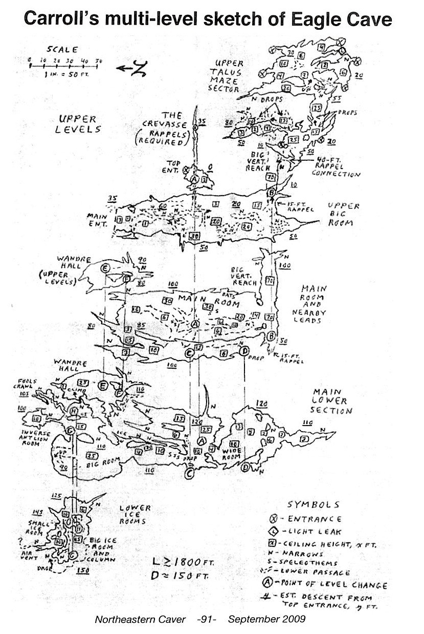
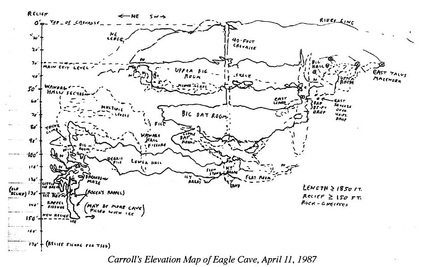
Eagle Cave is a gneiss fracture and breakdown cave on Chimney Mountain in the southern Adirondacks. Estimates of the cave’s size range up to 1850 feet of passages and 150 feet of relief. The “standard” published map of Eagle Cave is the 1978 Boston Grotto map (“the BG map”) that appeared in the 1979 NSS convention guidebook. A note on the BG map indicates that it is incomplete. While scanning Bob Carroll’s notebooks, I noticed that he shows quite a few passages not shown on the BG map. While Bob’s maps lack something in terms of accurate surveying, I thought it would be useful for all this previously unpublished data to see the light of day. In addition, Carroll presents maps of many smaller caves on Chimney Mountain, as well as location maps of the caves on the mountain.
First let’s compare the BG map with Carroll’s map of August 23, 1975. I’ve changed the orientation of Carroll’s map to better match the orientation of the BG map. Aside from nomenclature differences, note the following differences in Carroll’s map with respect to the BG map:
· An additional small passage northwest of Eagle Hall
· An additional small room and an extensive set of passages off the Crevice or Alley
· More than 300 feet of talus maze SE of the Bat Room/Main Room. This shows a connection to the Bat Room/Main room by a 40-foot rappel, and leads to several exits.
· An extensive “Lower Big Room”
Note that at this time Carroll did not know about the Ice Room Extension. He estimates Eagle Cave’s length at 1100 feet with relief of 130 feet. Curiously (and probably more accurately), the BG map only shows 100 feet of relief.
Bob’s next notebook entry on Chimney Mountain was dated September 27, 1975, where he says: “Lower levels of Eagle Cave yielded new passages, levels, and rooms. Miles Drake got into a lot of virgin cave and others found huge ice formations…Eagle Cave is currently rated at 1600+ feet…” But there is no updated map with this entry. The next entry is for October 11, 1975. Here Bob notes: “found ice rooms north of [the] big room…and found about 50 feet of virgin passage directly above.” “Eagle Cave is rated at 140+ feet of relief and 1700+ feet of passage…”
Unfortunately, the map details that go along with the October 11 trip, and a trip on October 18, 1975, are confusing and leave some unanswered questions. These maps show the lowest levels of Eagle Cave: those below the Main Room/Bat Room. The two maps show quite different sizes and shapes of the Ice Room and main part of the lowest level. They also show two very different shapes for what Bob called “Miles Drake’s New Section” or “Wandre Hall.” Wandre Hall and the “Inverse Ant Lion Room” do not appear on the BG map. Because of inconsistencies in Bob’s maps, and the question marks Bob wrote on the maps, I believe Bob never visited Wandre Hall. Also, it’s impossible to tell from the October, 1975 maps what the connections are between the Lower Big Room/Middle Lower Level and the lowest sections of the cave.
On April 11, 1987, Carroll returned to Eagle Cave with Roger Bartholomew. Associated with that visit is an elevation map of the entire cave, along a NE/SW axis, on notebook page H-123. On that trip, Bob and Roger “relocated Miles Drake’s ‘Wandre Hall’ exit that had been ‘lost’ since 1975,” but dotted lines on the map indicate that Bob didn’t enter Wandre Hall, and that the passage outlines are speculative. It’s interesting to compare Bob’s elevation map with the BG elevation map, since it’s easy to see the passages that are only on Bob’s maps.
This analysis of Carroll’s maps shows the need for somebody to produce a well-surveyed map that shows all the passages and rooms in Eagle Cave.