Notes on "other" Chimney Mountain Caves
as taken from Adirondack Trails With Tales (p. 205)
"Since the 1970's, new caves continue to be found, many of them ranging in length from 10 feet up to 400 feet of passage. Robert W. Carroll Jr., one of the Northeast's most recognized and dedicated cavers, spent a considerable amount of time on Chimney Mountain and made a number of discoveries.
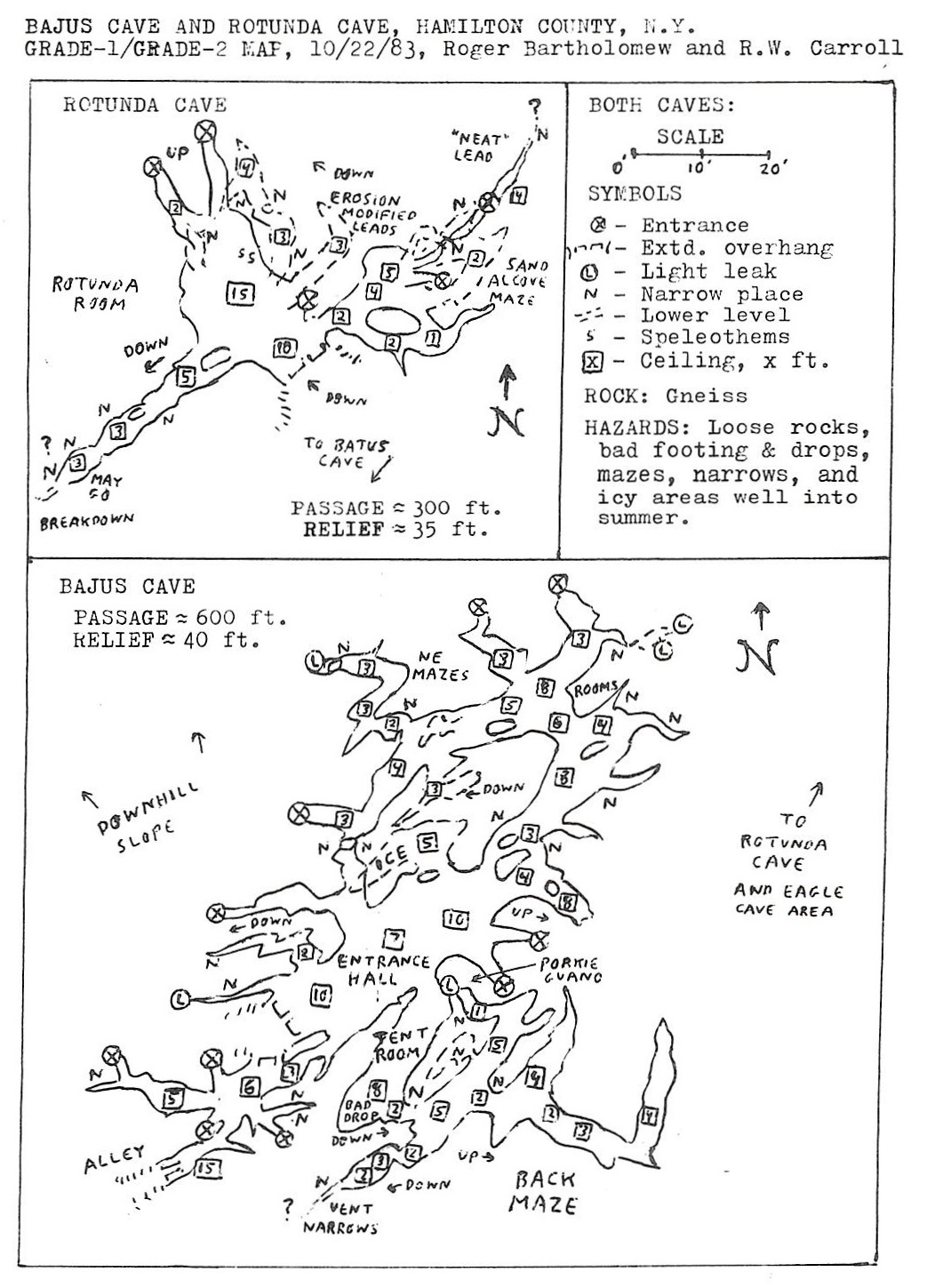
In 1983, Roger Bartholomew discovered two more caves - Bajus Cave (named after a youngster who accompanied him and found the entrance) and Rotunda Cave (named for its dome-like entrance room). Bajus is the second-largest cave on Chimney Mountain, with 600 feet of passages; Rotunda has 300 feet. Bartholomew also visited a number of other caves and gave names to some, such as Bottle Cave (a twenty-foot horizontal crawl).
Other cavers have also been busy at work exploring the rubble of rock near the top, and as of now over forty caves have been discovered."
‘Chimney Mountain Extras’ by Robert Carroll, Jr.
Taken from Issue 2 of the 1984 edition of Northeaster Caver
For about two decades, Roger Bartholomew has maintained a serious interest in Chimney Mountain in Hamilton County – despite occasional long absences from the Northeast and exposure to far larger and deeper systems in Europe, Texas, and Mexico. During the 1960’s, he descended Eagle Cave via the difficult 90-foot crevasse route. In 1971, I first saw this impressive cave. 1975 saw major efforts by NRO, Boston Grotto, and ADK Grotto that expanded Eagle to 1800 feet and explored numerous other nearly caves ranging up to 400 feet of passage. The area suffered heavy use and abuse later that decade and into the 1980’s with many fragile “coral” formations trampled under or vandalized. Sporadic explorations raised the area cave count to 36, but 400 feet seemed to remain the upper size limit on the “satellite” caves to Eagle.
In August of 1983, Roger returned to Chimney Mountain and found two new caves on the northwest slope. One was named Bajus Cave for a youngster accompanying him who found the actual main exit. The other was named Rotunda Cave for its curious dome-like entrance room. On October 22, we decided to explore these in more detail, check the area for more caves and possible effects of recent earthquakes, and resolve some questions of cave locations with respect to each other. The early October tremors appeared to have had few effects despite the unstable appearance of many gneiss fracture leads. The day’s efforts yielded three additional small caves, raised Eagle Cave to 1850 feet of passage, and “pinned down” the site of a huge cleft that had eluded pinpointing since 1978.
The southwest end of Bajus Cave had a large exit and room, off which went numerous brief leads and a parallel tent-shaped passage. A short but treacherous drop SE of the Tent Room led to a brief maze of crawls and lesser rooms. All leads soon ended, but one narrows we couldn’t negotiate had strong air currents. Another went upward toward light but then got into porcupine guano that we retreated from because of possible ticks. Back in the entrance hall, we checked short leads on the NW side, found ice in one room, and proceeded NE into mazework and more rooms that led to other exits. Lower levels terminated in sand and fragment plugs, and upper leads fared little better. The cave fell short of the hoped-for 1000 feet, but its 600 feet made it the second largest on Chimney Mtn. and fourth largest in Hamilton County.
Rotunda Cave had 300 feet but was geologically more interesting. The entrance room reminded me of the dome-like rooms in the Plymouth Caves in Vermont – but Rotunda is a gneiss tectonic system rather than a marble cave. From this, a SW lead looked more like the normal fracture-type passage, but the two NE leads showed definite erosion modification. To the NE was a shallow maze with much sand and more evidence of stream action. The Rotunda Room also had some “coral” modules where weathering appeared most severe. This and the other caves in the area suggest a complicated and long geological history of glaciation, stream erosion, and tectonic upheavals.
Those visiting Rotunda, Bajus, Eagle, and other caves on Chimney Mountain are urged to minimize impact on the remaining fragile features and to use caution when encountering drops, loose rocks, ice, and mazes. Although the 1983 tremors apparently had nil effect, one could be wise to use extreme care in times of high seismic activity.
‘Chimney Mountain Notes’ by Roger Bartholomew
Taken from the March Issue of the 1998 edition of Northeaster Caver
On September 27, 1997 I joined Greg and Dana Atwood, Greg and Sara Bowers, Ed Koslowski, Jason, Rick, Ann and others from Rochester who had camped out on Chimney Mountain, Hamilton County, NY. On July 9, 1994 I had found a lead on the west face of the eastern ridge on which the “chimney” is located on this trip I asked Greg to check it out. Greg crawled in about 10 feet and slid down a narrow crack to where the passage opened up a bit and he explored about 30 feet of passage. He made a sketch map of the cave and I told him to call it Atwood Cave. Robert Carroll, who had also joined the group, went to check out a small cave below the north side of the “chimney” and to do solo exploring.
On September 27, 1997 I joined Greg and Dana Atwood, Greg and Sara Bowers, Ed Koslowski, Jason, Rick, Ann and others from Rochester who had camped out on Chimney Mountain, Hamilton County, NY. On July 9, 1994 I had found a lead on the west face of the eastern ridge on which the “chimney” is located on this trip I asked Greg to check it out. Greg crawled in about 10 feet and slid down a narrow crack to where the passage opened up a bit and he explored about 30 feet of passage. He made a sketch map of the cave and I told him to call it Atwood Cave. Robert Carroll, who had also joined the group, went to check out a small cave below the north side of the “chimney” and to do solo exploring.
‘Carroll’s map of Eagle Cave and Chimney Mountain’ by Steve Higham
Taken from the March 2007 edition of Northeaster Caver
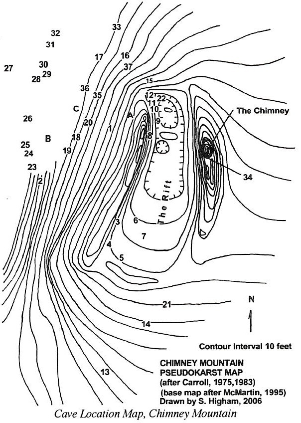
Now let’s look at Carroll’s Chimney Mountain pseudokarst maps [seen below], which attempt to show the locations of all the caves discovered on Chimney Mountain with respect to well-known topographic landmarks. I’ve used Bob’s location map and cave list dated October 22, 1983. I’ve transferred Bob’s cave locations onto a topographic map of the area (based on a map in Discovering the South Central Adirondacks by Barbara McMartin), and have redone his cave list into a table that also shows the notebook pages or Northeastern Caver pages that the caves’ maps are on. Due to uncertainties in Bob’s location maps, only the map location for the main entrance of Eagle Cave should be considered precise. The other locations are more an indication of the relative positions of all the caves on the mountain.
Now let’s look at Carroll’s Chimney Mountain pseudokarst maps [seen below], which attempt to show the locations of all the caves discovered on Chimney Mountain with respect to well-known topographic landmarks. I’ve used Bob’s location map and cave list dated October 22, 1983. I’ve transferred Bob’s cave locations onto a topographic map of the area (based on a map in Discovering the South Central Adirondacks by Barbara McMartin), and have redone his cave list into a table that also shows the notebook pages or Northeastern Caver pages that the caves’ maps are on. Due to uncertainties in Bob’s location maps, only the map location for the main entrance of Eagle Cave should be considered precise. The other locations are more an indication of the relative positions of all the caves on the mountain.